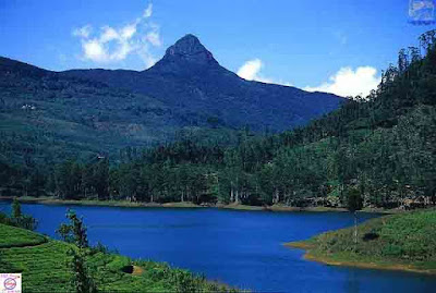
Sripada “mountain of Sacred Footprint of Sri Lanka” is an ancient pilgrimage site. This conical mountain of 2,243 m high has a unique distinction of being sacred to the followers of four religions. It is highly revered by followers of four religions: Buddhism, Christianity, Hinduism and Islamism.
Long before the development of these religions, however, this lush mountain was worshipped by the aboriginal inhabitants of Sri Lanka, the Veddas. They used to call it Samanala Kanda, Saman being one of the four guardian deities of the island.
Location:
A Mountain is located in the southern area of the Central Highlands in the Ratnapura district of Sabaragauwa province. The surrounding region to this mountain is largely forested hills and distinctly visible because no mountain of comparable size is nearby. This lush forested area surrounded near the mountain is home to several wildlife species varying from elephants to leopards, and including many endemic species.


Myths Related
According to a legend, it is believed that Lord Buddha during his third visit to Sri Lanka placed his footprint on the summit of this sacred mountain. So, the name Sripada-the sacred footprint. Again the Muslim followers believe that the footprint is of Adam (hence the name Adam’s peak) whereas Christians and Hindus believe that the footprint is of St. Thomas, the disciple of Jesus, as he brought Christianity to the country and God Shiva respectively. For Hindus, the name of the mountain is Sivan Adi Padham, because it was the world-creative dance of the Lord Shiva that left the giant footprint (5 feet 7 inches by 2 feet 6 inches).


Pilgrimage Session to
Today the pilgrimage season commences in December and continues until the beginning of the monsoon rains in April (from May to October the mountain is obscured by clouds). Pilgrims try to reach the peak before dawn, as the view of sunrise from the peak is spectacular. There are several approaches to reach the peak. The main ones being through the Hatton town and Ratnapura District.
Would you like to go Adam's Peak? Please E-mail your comment in the my mail box below, ( basuratravels@gmail.com ) I can help you it. Thank you! If you like this blog post, or find it useful, please share it on social media!
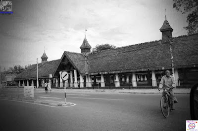
The historic market building at the Nupe Junction had been built by the Dutch in 1775 according to the notice board at the site but according to a Dutch Cultural Heritage site (Cultural Heritage Connections) this site was built by the British.
Either way this building at the Nupe has been used as a market during the British occupation in Matara. Built to be in the shape of the English letter ‘T’, this building has been constructed on pillars and tiled with round tiles. The supporting wooden frame of the clay tiled roof is elaborate and edged with lavish latticework. It is 15m in height and supported by massive white stone pillars. The roof is paved with typical Kandyan Era flat tiles (pethi ulu). A peculiar feature is the three small roofs above the main roof.

As the years grew on from the British times and till many years thereafter, this spacious Dutch Nupe edifice fell into disuse. It ultimately was in desolation and became the refuge of the roaming stray cattle. In the 1980s a portion of its building collapsed, when the department of Archaeology took over its functions of restoring the building. Still later its further restorations came under the Urban Development Authority which completed its restoration work in 1989, when it was handed over to the Hunupitiya Gangarama Temple which ran a cottage industry.
Today this building is used to house various exhibitions.
Would you like to go Nupe, Matara Tour? Please E-mail your comment in the my mail box below, ( basuratravels@gmail.com ) I can help you it. Thank you! If you like this blog post, or find it useful, please share it on social media!

Nilagala Forest lies bordering Gal Oya National Park and covers a catchment area of Senanayake Samudraya. Gal Oya which is one of the main water sources of Senanayake Samudraya falls to reservoir from the Nilgala.
‘Nilgala’ literally means ‘blue rock’. According to Gunatilleke & Gunatilleke (1990) the major vegetation type is lowland tropical dry mixed evergreen forest. The general climatic conditions in the Nilgala area can be described as moderately cool, turning humid during the northeast monsoon season.
Nilgala forest is also important as a major watershed for Gal Oya and Panmedilla Oya throughout the year. There are several peaks within the Nilgala forest area with “Yakun Hela” being the highest (700 m).
Nilgala forest is also rich of archaeological monuments, such as prehistoric and historical Buddhist monasteries.


The Nilgala forest comes under both Department of Wildlife Conservation and the Department of Forest Conservation. About 9000 hectares in the Eastern region comes under the Wildlife Department. This area is accessible to general public. About 13,000 hectares of the forest belong to the Forest Department and no road network or facilities exists to enter this area. The total area of the Nilagala Forest including the surrounding savanna grasslands is around 26,000 hectares.
The access to the Nilagala Forest is between Bibile – Inginiyagala Road. The turn off is at Bulupitiya which is 42 kms from Inginiyagala and 21 km from Bibile town.
The forest office maintains 4 camping sites. Seenukgala Camping Site which is close to the forest office, Mahadorowwa camp site and Paraviyan Ara camp site and the Makara camping site.
There is also bungalow which comes under Gal Oya National Park located at Lokgaloya. This bunglow has a capacity for 10.
Nilgala has 3 jeep tracks. One from Nilgala to Makara, another to Pothuliyadda through Mullegama, Thumbarenuwa and Kebellabokka and the third to Mahawela through Dimbuldena and Kotabowa.
The place which the Gal Oya river disappear the Senanayake Samudraya is called Makara. That name has its origin in the fact that there is a natural tunnel located at this place. Legend has it that the original name was “Makara Kata” or Dragon’s Mouth, coined because the water goes through the tunnel. The Makara Kata had become simply Makara with time.


There is no Makara Kata to be seen now, since the sand where the Kakara Kata was located has all been washed away around five years ago. Now all you can see are huge rocks, between 20 and 50 feet tall and the place where the Makara Kata used to be. Makara is also accessible by boat starting from the Senanayake Samudraya dam.
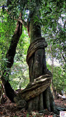
the major vegetation type of the Nigala Forest is lowland tropical dry mixed evergreen forest. Commonly found trees include Aralu (Terminalia chebula), Bulu (Terminalia bellirica) and Nelli (Phyllanthus emblica). Other
trees such as Kumbuk (Terminalia arjuna), Kon (Schleichera oleosa) and Kaluwara (Diospyros ebenum) are also present. Savana grassland areas consist of Kudumberiya, Kukurumana, Pangirimana, Mana, Iluk and similar.
The forest consists of its share of larger animals from elephants to dear to Buffaloes, the park is more popular with bird watchers.
This forest consist of 4 main peaks Nilgala, Danigala, Yakunnahela, Kahata Aththa Hela and Makadakanda. The Nilgala peak stands out of the rest with its odd shape.
No study has been done on the archaeological value of the Nilgala Forest so far. Some of the know remains consist of a part of a ancient structure which stumps of about 25 stone pillars and the Mukkaru Sohona which can be seen on the Makara Route.


Andagala is another location where ruins of a possible castle has been located. A bed carved from a rock gives its name and you can see works with massive granite blocks including part of a protective wall is scattered every where. Equally prominent are the works of the treasure hunters who has had a free ride among these ruins.
The ruins of a ancient cave temple at Kahata Aththa Hela known as Kahata Aththa Hela Purana Gal Ge is another archaeological site in the forest. Around this lena you will see more ruins scatted around.
At Andayampola remains of a possible ancient fortress can be also seen. Unfortunately no formal archaeological study has been carried out on these sites other than by treasure hunters.
Size - approx. 26,000 hectares
Main attraction - Flora and Fauna
Would you like to go Nilgala Forest Area? Please E-mail your comment in the my mail box below, ( basuratravels@gmail.com ) I can help you it. Thank you! If you like this blog post, or find it useful, please share it on social media!


